
[ad_1]
FORT COLLINS, Colo. – The U.S. Geological Survey and the Bureau of Land Management today released a collaborative report with new information and tools to support effective management of millions of acres of BLM public lands. The report underscores the value of a landscape approach to management, and shows that the BLM manages some of the largest areas of intact public lands in the west.
“By evaluating multiple resource uses within and across landscapes through a science-based approach,” said USGS lead author Sarah Carter, “managers will be able to think bigger and plan better than ever before to provide multiple benefits for current and future generations of Americans.”
This report provides BLM with tools to advance a landscape approach to planning and management on the 246 million acres of western public lands they manage for the benefit of the American public. The report will also inform future BLM planning, monitoring and conservation initiatives, including the development of a coordinated nationwide multiscale monitoring effort.
“BLM and other resource managers are facing ever greater challenges – such as increasing wildfires and intensifying pressure to meet U.S. energy demands on U.S. lands,” said Kevin Miller, co-author with the BLM. “To effectively balance the health of these public lands with their diverse uses – such as recreation, livestock grazing, energy development and wildlife conservation – the BLM has adopted a landscape approach to resource management.”
“A landscape approach,” said Carter, “relies on the best available science to inform management actions and considers many perspectives to identify potential management issues and alternatives across large landscapes.” Today’s report strengthens the science foundation needed to implement a landscape approach: seeking broad participation by interested stakeholders, tackling complex issues, engaging a variety of scientific disciplines and striving to achieve sustainable social, environmental and economic outcomes across landscapes.
To improve the understanding and management of complex systems, the authors of the report emphasized the need to collect data at multiple spatial scales, from individual field samples to satellite imagery. Such data support both project-level decisions and landscape-scale management, leading to more effective planning and more informed decisions.
A series of Rapid Ecoregional Assessments commissioned by the BLM across the west helped USGS and BLM scientists to identify key management questions that need to be asked and answered at broad scales to understand landscapes and effectively plan for future land uses. Importantly, researchers also identified opportunities for using broad-scale data to inform on-the-ground monitoring by the BLM Assessment, Inventory, and Monitoring Program.
Other advances include a new approach for quantifying ecological integrity across multiple-use landscapes such as areas that may be important for grazing, wildlife conservation and recreational use. The USGS introduced a method and identified specific metrics that the BLM and other multiple-use agencies, such as the U.S. Forest Service, can use to assess the integrity or health of the lands they manage. “Managers and the public alike can use this information to gain a better understanding of the condition of ecological systems across all federal lands,” said Carter.
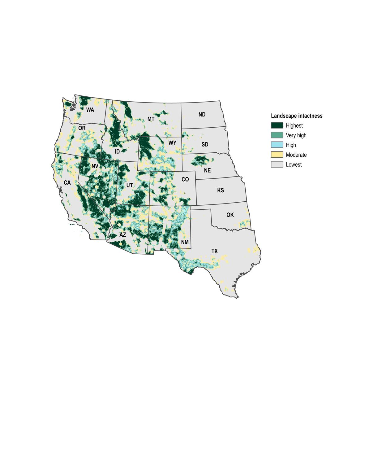
This study also quantified landscape intactness – that is, the degree of naturalness of a system – across the western U.S. based on the surface footprint of urban development, cultivated agriculture, transportation, energy and mining. The resulting landscape-level index indicates that BLM has responsibility for managing some of the largest area of intact public lands in the country. These data are available to the public for use in planning and management applications.
Managing complex landscapes for multiple uses requires new approaches, new tools, and multiscale data to balance different uses and understand the cumulative effects of management decisions across time and space. This report provides BLM with tools to advance a landscape approach to planning and management on public lands across the west. The report will also inform future BLM planning, monitoring and conservation initiatives, including the development of a coordinated nationwide multiscale monitoring effort.
The USGS Open-File Report, Multiscale Guidance and Tools for Implementing a Landscape Approach to Resource Management in the Bureau of Land Management, was edited by Sarah K. Carter (USGS), Natasha B. Carr (USGS), Kevin H. Miller (BLM), and David J.A. Wood (USGS).
This project was supported by the BLM and USGS.

Landscape intactness for the western conterminous U.S. (Credit: USGS. Public domain.)
USGS provides science for a changing world. For more information, visit www.usgs.gov.
Subscribe to USGS News Releases via our electronic mailing list or RSS feed.
[ad_2]
Source link

- Warmer water could cool Montana’s trout fishing economy - September 7, 2022
- Water Released from Crystallizing Magma can Trigger Earthquakes in Yellowstone - September 5, 2022
- Thermal Infrared Remote Sensing at Yellowstone 101 - August 29, 2022
Related posts:
 New Report Highlights Declining Sagebrush Ecosystem, Provides Foundation for Next Generation of Conservation and Management
 President Proposes $971.2 Million FY 2021 Budget for USGS
Water-Level Changes in Northeast Twin Cities Lakes Vary with Landscape Setting
President Proposes $971.2 Million FY 2021 Budget for USGS
Water-Level Changes in Northeast Twin Cities Lakes Vary with Landscape Setting
 USGS La Crosse Science Center Opens Doors for Interactive Experience