[ad_1]
Note to Editors: In the public interest and in accordance with Federal Aviation Administration regulations, the USGS is announcing this low-level airborne project. Your assistance in informing the local communities is appreciated.
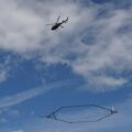
Starting on or around January 4 and lasting two to three weeks, a helicopter towing a large hoop from a cable will begin making low-level flights over northeast Wisconsin between Calumet and Door counties.
The low-flying helicopter will collect and record geophysical measurements as part of a U.S. Geological Survey project to improve below-ground geologic maps. Scientists will use data collected during the survey to map shallow bedrock and glacial sediments in parts of Door, Kewaunee, Brown, Manitowoc, Calumet, Sheboygan and Fond du Lac counties. The maps will help the Wisconsin Department of Agriculture, Trade and Consumer Protection and the Wisconsin Department of Natural Resources develop new water-quality and land-use standards.
The helicopter will fly in a grid pattern relatively low to the ground, hundreds of feet above the surface. A sensor that resembles a large hula-hoop will be towed beneath the helicopter to measure tiny electromagnetic signals that can be used to map features below Earth’s surface. Survey flight lines will be separated by a half mile, so the helicopter system will only be visible from any particular location for a short period of time.
The USGS is contracting with SkyTEM ApS, a specialty airborne geophysical company, to conduct the survey. The helicopter will be operated by experienced pilots from Sinton Helicopters who are specially trained for the low-level flying required for geophysical surveys. The company works with the FAA to ensure flights are safe and in accordance with U.S. law.
The USGS-led study is being conducted in partnership with the Wisconsin Department of Agriculture, Trade and Consumer Protection, Wisconsin Department of Natural Resources and Wisconsin State Geological and Natural History Survey
[ad_2]
Source link

- Warmer water could cool Montana’s trout fishing economy - September 7, 2022
- Water Released from Crystallizing Magma can Trigger Earthquakes in Yellowstone - September 5, 2022
- Thermal Infrared Remote Sensing at Yellowstone 101 - August 29, 2022