[ad_1]
What the USGS is Doing
Crews are in the field to keep the USGS’s streamgage network of about 11,300 instruments working properly, perform on-site measurements of flooded rivers, and measure high-water marks as flood waters recede.
In the coming days and weeks, USGS crews will continue to monitor streamgages, make flood measurements in the field to determine how much water is flowing, and provide other data used for flood forecasting and flood-control reservoir management.
Flood Information is Critical to Public Safety
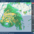
The data from the USGS’s nationwide streamgage network provides vital information to the U.S. Army Corps of Engineers, the National Weather Service, and other federal, state and local agencies, enabling them to make river forecasts, operate flood control structures, and make important emergency management decisions. Frequent measurements are needed during flooding to document possible changes in the stream’s channel, which could affect the river level.
Responding during COVID-19
The response to spring flooding is complicated this year by COVID-19. The USGS is working to provide flood information that is critical to the public safety while also keeping employee safety and well-being a priority.
“Our field crews are working long days to help provide critical streamflow information for flood forecasting,” said USGS National Flood Hazard Coordinator Karl Winters. “Despite the challenges associated with COVID-19, our field crews have made nearly 800 streamflow measurements per week over the last six weeks.”
USGS water science centers are thoroughly evaluating needs for streamflow measurements and prioritizing streamgages most useful to flood forecasting and management.
Field crew partners are traveling to streamgage sites in separate vehicles, often with single-person crews, wearing appropriate personal protective equipment and practicing social distancing. Overnight trips are limited, so crews are often working longer days to make round-trip visits to sites. Crews are also leveraging the many tools made available to work from home and remotely meet with others when possible.
Despite the recent challenges, USGS crews made more than 20,000 streamflow measurements nationwide between January 1 and April 20, 2020.
Looking Towards the Future
As some states hit by severe weather begin to return to normal, others are preparing for what’s to come or dealing with continued flooding and the dangers that come with it. As snowpack is expected to continue to melt across the West and hurricane season begins on June 1, the USGS will continue to monitor stream conditions and use data collected to prepare for current and future flood events.
For up-to-date info on conditions in your area visit the USGS WaterWatch website. Sign up for high-water alerts at the USGS WaterAlert website.
[ad_2]
Source link

- Warmer water could cool Montana’s trout fishing economy - September 7, 2022
- Water Released from Crystallizing Magma can Trigger Earthquakes in Yellowstone - September 5, 2022
- Thermal Infrared Remote Sensing at Yellowstone 101 - August 29, 2022